Aventura 2 Challenge TwoNav
An extreme adventure in the Alps in the most risky winter weather conditions. The route will put the new Aventura 2 GPS to the test in the most extreme conditions.
Would you dare trekking through the Alps?
THE CHALLENGE
Experience the Aventura 2 Challenge with TwoNav, a crossing through the Austrian Alps, with the participation of Stefi Troguet, from Andorra, Ferran Latorre, from Spain, Elisa Deutschmann, from Germany and Pierre Vignaux, from France. The route we have chosen to test our new Aventura 2 GPS is 64 km long and has 4.650 m of possitive elevation, a journey of 35 hours in 4 stages that our athletes will have to endure under the most extreme weather conditions.

Aventura 2 Challenge completed!
After finishing the Aventura 2 Challenge yesterday in the Dachstein mountains of Austria, our team of brave alpinists, already arrived in Chamonix to go back home, decided to celebrate the end of the challenge skiing in Vallée Blanche, downside the Mont Blanc. Thanks to the GPS Aventura 2, they could enjoy the good weather going down the mountain safely, allowing a spectacular finale for this risky winter challenge.

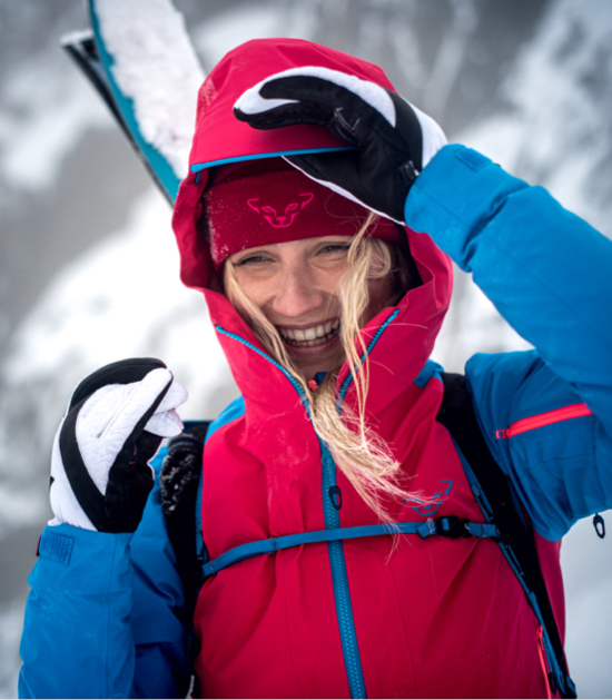
Stefi Troguet
She's a woman, an expert alpinist and excellent skiier, who has made herself a place in the world of alpinism in very short time. She has already reached Nanga Parbat peak (8.126 m high) and Manaslu (8.163 m high) without oxygen during 2019 and is already dreaming to climb the 14/8000. She is also leading on social media reclaiming the role of women in the world of extreme outdoor sports worldwide.
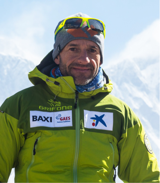
Ferran Latorre
His life has always been associated with the number 14! There's a reason why he's one of the few Catalan climber to have summitted the 14/8000ers. When he was 14, his parents signed him up with the Hiking Club of Catalonia, where he trained as a mountain and rock climber. He also worked for 14 years as a cameraman on the TVE show 'Al Filo de lo Imposible'. He has gone on expeditions all over the world: Asia, Greenland, Antarctica, the South Georgia Islands, USA... He's also had the opportunity to film great climbers, such as Juanito Oiarzábal, Iker Pou, Josune Bereziartu and Edurne Pasaban.
Elisa Deutschmann
The German athlete defines her life as a mix of enjoying nature and the freedom in the mountains. She loves outdoor sports and she's always open to new things, which is why she signed up for our Aventura 2 Challenge. The activities she's most into these days are ski mountaineering, paragliding, sailing, climbing, hiking and even kitesurfing. She's also studying design in Munich, where she is focusing on designing functional sports clothing.
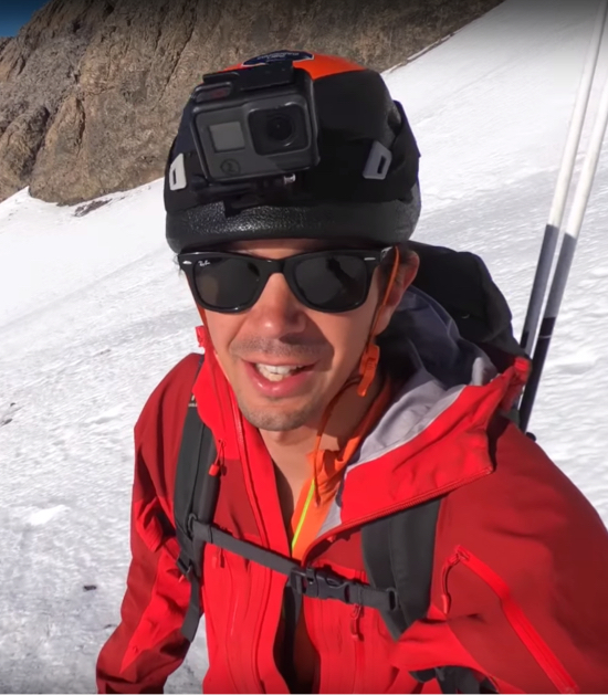
Pierre Vignaux
Radical 27-year-old French mountain photographer fills his social media feeds with content from his most impressive trips, sharing his take on life and his experiences in the mountains. Pierre bivouacs at least 20 nights in the winter season, fearless of the extremely low temperatures that could put his life at risk. He's the perfect athlete to test the durability of the battery in the Aventura 2 GPS!
AVENTURA 2 CHALLENGE STARTS TODAY
Our four explorers, equipped with the new Aventura 2 and relying on the TwoNav ecosystem to guide them through the Alps in the middle of winter, have a 64-km long route ahead of them with an elevation gain of 4,650 m. It's a cross-country skiing trek that will take place over 4 stages, one per day. In the first stage, the TwoNav team will leave from Lake Traun. What surprises does this stage have in store?
DAY 1: CRAZY WEATHER IN THE ALPS
Bad weather conditions have forced the team to rethink the route: thanks to the Land software, they have been able to define a more direct and safe itinerary to the refuge where they have spent the night (Simoneyhütte 2,203 m). At 1,900 m, the strong wind has made the new route even more dangerous. But thanks to Aventura 2, our team has managed to get safe and sound to the shelter, where they have spent the night to rest and recharge the batteries before the next stage.
DAY 2: CONQUERING DACHSTEIN HIGHEST PEAK
On this stage, the team travelled along the backbone of the Dachstein massif. They climbed Dachstein highest peak (2963 m) in just one day. It was a hectic and challenging day, specially due to the strong snow and wind. In spite of the risk of avalanche, our team made it to the night shelter just before the storm started. Great job team!
DAY 3: RE-DESIGNING THE ROUTE WITH LAND
The third stage was the hardest: due to bad weather and the high avalanche warning, our team has had to return to Hallstatt. Thanks to Land, in the morning they have been able to re-design a new route and upload it to the GPS Aventura 2, so they could return without problems to the charming little town in the Alps.
DAY 4: THE LAST STAGE
Congratulations to the Aventura 2 Challenge ambassadors! Our team completed this winter challenge. Stefi Troguet, from Andorra, Ferran Latorre, from Spain, along with Frenchman Pierre Vignaux and German Elisa Deutschmann, with her husky Finn always at her side, were up to the task of completing the route along the Dachstein peaks, in the Hallstatt region of the Austrian Alps. Each stage was a challenge in itself, as they encountered snow, strong winds, extremely low temperatures and tough mountaineering sections en route.
TWONAV ECOSYSTEM
A technological ecosystem designed for maximum customization
Aventura 2 is much more than a simple mountaineering GPS device. This innovative unit offers extreme functionality and is part of a complete technological ecosystem that lets you enjoy your outdoor adventures safely and reliably. In order to properly plan an extreme outdoor adventure with the Aventura 2 Challenge, good preparation is essential so that you can not only enjoy the experience, but analyze it afterward. With the TwoNav ecosystem you can:
Create a route in Land
The track we're going to follow during the Aventura 2 Challenge was created and edited using Land software (Windows/Mac).
Find out more on LandQuality Maps
The route was analyzed in great detail thanks to the wide range of maps from all over the world that is available in our map store.
Find out more on MapsNavigating with the Aventura 2 GPS
The Aventura 2 GPS lets you navigate outdoors on the most extreme routes safely.
Find out more on Aventura 2Sharing the Challenge on the GO-Cloud
And at the end of the challenge, the participants will be able to share their activity automatically on Strava, Training Peaks, Twitter or Google Drive.
Find out more on GO Cloud
Storing and analyzing tracks

Online routes partners
IGN Rando, FFCT...

Map Store
Wide variety of maps from all over the world


Creating and analyzing routes

Emergency alerts and Data transmission

Support App
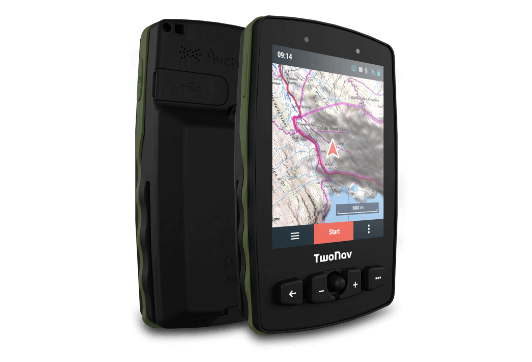
NEW AVENTURA 2 GPS
Designed for extreme conditions
Designed specifically for mountaineering, climbing and other high-risk, long-duration outdoor sports, the Aventura 2 GPS is a robust device built to withstand the moxt extreme weather conditions. With a functional and appealing design, the Aventura 2 features a large touch display with the latest tech, and satellite positioning that connects to the GPS and Glonass networks, and the new European Galileo network.
Follow Aventura 2 Challenge at every stage of the adventure in our social media.